
Details
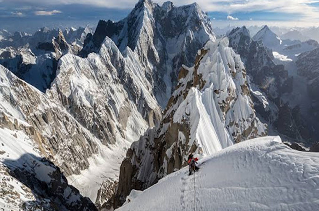
Link Sar, a striking peak nestled within the Masherbrum mountains of the Karakoram Range, stands at an impressive elevation of 7,041 meters (23,100 feet) above sea level. Located near notable mountains such as K7 (6,934m), K6 (7,282m), and the Charakusa and Kaberi Glaciers, these peaks in the Gilgit-Baltistan region of Pakistan are renowned for being some of the highest and most awe-inspiring landscapes in the world. The area is often described as a climber’s paradise and a dream destination for mountaineers and nature enthusiasts alike, with its pristine beauty untouched by human development. Since 1969, numerous attempts have been made to conquer Link Sar’s summit, but due to its remote location and challenging terrain, it remains a highly difficult peak to summit. The most recent attempt occurred in 2015 when Jon Griffith and Andy Houseman reached Link Sar West (6,938 meters) after a second attempt over two years. Unfortunately, Griffith faced health complications during the ascent, preventing them from reaching the main summit, and they had to descend. Griffith later remarked that although it was disappointing not to reach the main peak, they had no choice but to turn back, as continuing would have risked their safety in the challenging conditions. The Link Sar Expedition targets the Northwest face of the peak, yet the main summit remains unexplored to this day. Two primary routes lead to the summit: Hushe Valley and Kondus Valley, with the ideal time for the expedition being between June and August. The Karakoram Range stretches across Pakistan and China, forming a 500-kilometer-long and 200-kilometer-wide mountain chain. It hosts some of the world’s tallest peaks and is also home to significant rivers, such as the Hunza River and Indus River. The range encompasses several valleys, including Skardu, Hunza, and Gilgit, with each offering unique cultural and natural experiences. Embarking on a Link Sar Expedition is a journey through the Karakoram Mountains, where trekkers and climbers are treated to breathtaking views of towering peaks and vast glaciers, many of which are among the largest on earth. Services for this expedition typically include hotel accommodation, government permits (required for peaks higher than 7,000 meters), domestic flights, chefs, experienced tour guides, visa assistance, porters, camping gear, daily meals, and kitchen equipment, ensuring a comprehensive and supported experience in this remote, spectacular region.
Itinerary
• Arrival: Fly into Islamabad, Pakistan’s capital city. • Activities: Orientation meeting, equipment check, and briefing with the expedition team. Rest and acclimatization to the local time zone.
Fly Islamabad to Skardu
Rest Day and Preparation Day in Skardu
Drive to Hushe by jeeps via 6-7 hours 120 km. Hushe is starting point of our trek. It is a spectacular drive from Skardu to Hushe. The jeep road crosses the Shyok River and passes the villages of Khaplu, Macholo, Kanday and Khaney.
After breakfast meet porter and start our trek from Hushe to Saicho 4-5 hours, 9.3 km.
Trek to Spangser 4-5 hours 8.5km. Head east from Saicho into the ablation valley north of the Tsarak Tsa Glacier. The sharp spires of K7 and Link Sar are visible ahead. Tikchumik (small spring), which is in the ablation valley at the base of the ridge west of the Chogolisa Glacier’s, has good water. Continue along the base of the ridge to the Chogolisa glacier’s west margin. Cross this glacier to the green and flowered Spangser above the confluence of the Chogolisa and Tsarak Tsa glaciers. Spangser (4000m) is the highest pasture and is used mid-July to mid- August. Granite slabs rise above Spangser and Namika (6325m) towers across the Tsarak Tsa Glacier.
Trek to base camp 4 hours 11km, through the ablation valley north of the Tsarak Tsa glacier, at the time over difficult terrain to K7 base camp.
24 days in Charakusa base camp for Link sar peak climbing.
Trek back from Charakusa base camp to Saicho.
Trek from Saicho to Hushe 4-5 hours 9.3 km.
Drive from Hushe to Skardu 6-7 hours.
We fly back to Islamabad. Afternoon is free for exploring. If our flight is cancelled due to bad weather, we will start the drive to Islamabad travelling for 9 hours along with Indus River to reach Chilas.
Enjoy a free day in Islamabad for exploring, sightseeing and shopping. Note: If our flight on day 18 cancelled we will spend 11-12 hours driving from Chilas to Islamabad via Babusar Pass 4173m
Transfer to Islamabad airport for return flight.
Services
| Lodging at base camp (single supplement) |
| Full base camp with dinning tent, bathroom, showers & solar charge |
| All internal/domestic transport |
| All domestic flights |
| 50kgs (110 lbs) personal baggage |
| All meals during trek and at base camp (B,L,D) |
| Group emergency equipment/satellite phone service with fixed calling charge |
| Two nights stay in Islamabad hotel on arrival and two on return (bed & breakfast only) |
| Staff insurance (guide, cook, kitchen staff, assistant(s) & porters etc) |
| Experienced cook from Pakistan |
| Kitchen staff |
| Porters for all expedition supplies |
| Solar power at base camp |
| Electricity generator (backup for high voltage devices) |
| International airfare |
| Permit/royalty fee according to number of persons |
| Personal climbing equipment, clothing & sleeping equipment |
| Group climbing gear (rope, ice crew, snow bar, EPI gas, cooking pots and others) |
| Mountain climbing rescue and evacuation insurance policy - mandatory |
| Lodging and meals above base camp |
| Any service above base camp |
| Communication radio (walkie talkie) |
| Weather reports |
| Personal equipment cargo to/from Islamabad |
| Pakistan visa fee |
| Tips/gratuities to staff, cook, assistant(s) of US$ 250 per person in total |
| Meals in Islamabad |
| Extra hotel nights after the climb |
| Trip cancellation insurance |
| All expenses incurred in the event of early wind-up/summit (extra hotel nights, meals at hotels, evacuation) |
| Charges incurred due to delays beyond the control of Karakorum Alpine Guide (Force majeure) |
| Personal communication (phone, fax, e-mail) between Pakistan and home country. |
Google Map
Photos

Muhammad Ishaq
CEOI am a professional mountaineer and expert mountain guide in the Karakoram Range. In addition to my guiding work, I have recently opened a climbing training center in Huahe Valley, where I aim to share my knowledge and experience with aspiring climbers and adventurers.
Feedbacks